Geospatial & Land Surveying
LiDAR Scanning Saves Time and Costs
KPM Franklin’s Geospatial & Land Surveying department is using light detection and ranging (LiDAR) scanning technologies to provide clients with highly accurate data for ALTA/NSPS, boundary, topographic, tree, as-built and other land surveying project deliverables.
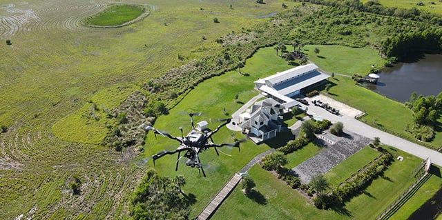
We combine drone-based aerial and ground-based terrestrial scanning to capture millions of precise data points in hours, not days.
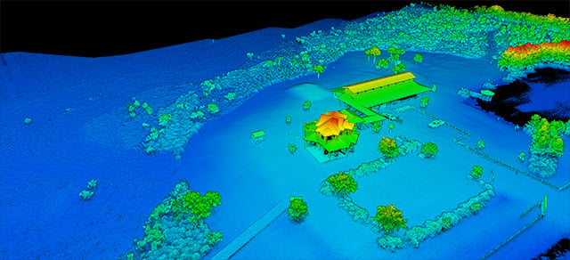
The millions of data points are processed to form a high-density point cloud. Survey data extracted from the point cloud for use in 3D modeling and importing into Civil 3D for civil engineering design and Revit for architectural design.
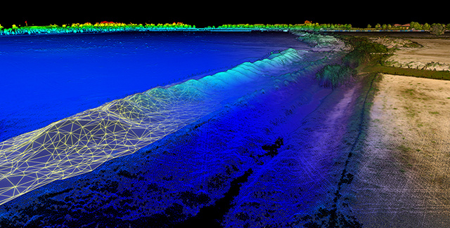
These advanced LiDAR technologies provide much greater detail than traditional survey methods for mapping terrain, ponds, structures, hardscapes and other surface features with centimeter accuracy.
LiDAR scans scale easily for small, medium and large projects.
Aerial LiDAR Scanning
Aerial surveying uses light detection and ranging (LiDAR) scanning to drastically decrease survey lead time and reduce costs while also providing the benefits of 3D modeling at scale.
The larger the project requirements, the greater the return from an aerial LiDAR scan. In the right project environment, aerial LiDAR scanning can reduce two weeks of traditional field survey time to as little as two days.
The benefits are faster data collection than traditional methods, reduced fieldwork and lower costs. For civil engineers, processed aerial LiDAR data is ideal for drafting initial conceptual site plans before diving deeper into overall site design.
Terrestrial LiDAR Scanning
Terrestrial LiDAR uses a stationary tripod-mounted scanner to capture millions of precise data points for generating dense point clouds of complex spaces such as buildings, utilities, infrastructure and other surface features.
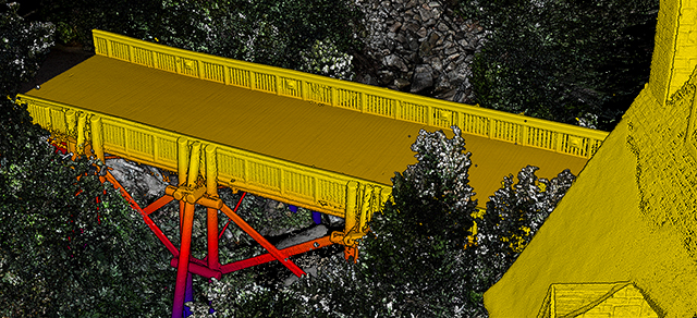
The result is comprehensive datasets that minimize errors. It complements aerial data with sub-millimeter precision, capturing details that drones might miss in shaded areas and underneath structures like bridges and overhanging building features.
Terrestrial LiDAR also is perfect for scanning building interiors to capture walls, ceilings and other structural details for creating highly accurate 3D models for architectural design.

A drone-based aerial LiDAR scan collects millions of raw data points to form a high-density point cloud. Survey data extracted from the point cloud provides much greater detail than traditional survey methods while reducing the need for assumptions in a design environment.

Processing software can render the point cloud into a 3D model for creating highly accurate surface, elevation and terrain maps.

Ultra-high-resolution and highly accurate terrestrial LiDAR scans identified erosion control issues at waterline under this bridge.
Evaluate your Project with a 3D Flythrough
We can help you evaluate your project site by creating a 3D animated flythough video that provides an accurate representation of the intricate details within the built-up space, such as buildings, fencing, sign posts, trees, shrubs and other above ground features.
The animated 3D flythough is rendered from the the high-density point cloud of raw data points collected through aerial LiDAR scanning and provides another fast option for a land developer to evaluate future uses for the site.
Quick Reference Digital Archive Saves Costs
When transitioning a project from due diligence to the design phase, a developer will occasionally need more information than requested in the original survey scope for drainage, roadway, utilities and other onsite or offsite improvements.
Aerial LiDAR scans can collect data points beyond the original scope to create a digital archive for quick reference throughout the project life cycle yielding significant cost savings by project completion.
Electric Utility Transmission Line Mapping
For about half the price of a helicopter flight, we can fly electric utility corridors to map transmission lines, insulators, poles and other structural assets within centimeters of their exact location for identifying areas where encroaching vegetation could cause an outage.
We can create a 3D model and output ultra high-resolution images for the following.
- Calculating pole height and lean
- Determining exact distance between transmission lines and vegetation
- Identifying locations where older transmission lines are sagging and need maintenance
Material Stockpile Volumetric Calculation
KPM Franklin's field crews love dirt! We can create highly accurate volumetric calculations of material stockpiles of any size or shape in a fraction of the time it takes by traditional surveying methods.
Our LiDAR scanning drone can repeat the same flight path to monitor changes in volume over time. This is an invaluable tool for projects where precision, consistency and timely data can make all the difference.
We combine an experienced and dedicated team with cutting-edge technology to ensure that you receive top-tier service at every step throughout this process.

Our Services
- LiDAR 3D Scanning
- 2D Surface Maps - Digital Elevation Model (DEM), Digital Terrain Model (DTM) and Digital Surface Model (DSM)
- Georeferenced Orthomosaic Maps
- Electric Utility Transmission Line Mapping
- Material Stockpile Volumetric Calculation
- Utility Corridor Mapping
- Asset Inspection and Management
- 3D Data Modeling and Visualization
- Aerial Thermal Imaging
